Thursday, April 25, 2013

Thursday 4/25

Temperature: 39°F (High 48°F)
Humidity: 73%
Pressure: 1023.4 mb
Wind Speed: W 9 mph

When everyone has been waiting and expecting the warm weather to finally come and stay, the coldness just won't leave. Today is another chilly day, with a consistent west wind and altostratus clouds. The jet stream is in a meridianal flow pattern again, and Wisconsin is centrally located in the trough. This dip in the jet is allowing this cold weather to hang out a little bit. With less than a week left of April, I think there's a good chance we won't see 70°F before May.

Sunday, April 21, 2013

Sunday 4/21

Temperature: 44°F (Low 39°F)
Humidity: 71%
Pressure: 1019.9 mb
Wind Speed: E 6 mph

The never-ending winter continues. Today was a nother cold and dreary day. It was overcast all day, with low stratus clouds, sometimes producing some light precipitation. For everyone who is hoping that this weather will finally improve, don't hold your breath. There is another flurry of precipitation coming tonight, most likely only rain, it shouldn't get cold enough for snow. As you can see, directly to our west is a stationary front. Directly behind that is a large high pressure system that would clear some of this dreariness up, but that stationary front is keeping it in place.


If you hate this weather as much as I do, you can thank the jet stream. You can see that from the way it is positioned in, Eau Claire is sitting at the bottom of the trough. The divergence in the upper atmosphere is creating a void for the surface air to rush into. That air condenses into clouds and creates this consistent bad weather.

Tuesday, April 9, 2013

Tuesday 4/9

Temperature: 37°F (High 40°F)
Humidity: 96%
Pressure: 1017.4 mb
Wind Speed: NE 3 mph

Today is a very rainy day. Since about 9:00 this morning, there has been a consistent rain coming down. It's nothing torrential, but certainly not just a drizzle. Here in Eau Claire, everyone is preparing for a major flood to happen on the Chippewa River. Fortunately, it doesn't look like we'll see anything to extreme. I looked at the flood hydrograph for today (below) and even with the projected rainfall over the next 24 hours, we will barely come close to the "minor" flooding stage. In other words, the river is going to be high enough to be much more exciting than last spring, but we'll be safe from serious flooding. Below is the flood hydrograph from the Chipp. It can be found at the National Oceanic and Atmoshperic Administration website. The direct link is http://water.weather.gov/ahps2/hydrograph.php?wfo=mpx&gage=eclw3


Monday, April 8, 2013

Monday 4/8

Temperature: 37°F (High 46°F)
Humidity: 93%
Pressure: 1009.1 mb
Wind Speed: NE 3 mph

Today is a typical gloomy spring day. The sky has been covered with stratus clouds all day, and there has been quite a bit of humidity in the air, which was visible earlier in the fog. The temperatures have actually been pretty pleasant though, and there's hardly any wind. In Wisconsin, the temperatures are still fluctuating between warm and cold, and we're still waiting for the temperatures to heat up evenly all the up through the atmosphere. Right now, the upper atmosphere is still much colder than the surface temperatures, and we won't see constant warm temps until it warms. How does it warm, you ask? Well as the winds shift to the south, we will see more warm air come our way, but to really heat up the upper atmosphere, we need storms! The vertical growth of thunderclouds release immense amounts of energy high in the atmosphere, which helps to warm it up. There aren't any storms today, but hopefully we will be seeing some soon. There are some major low pressure systems that are constantly forming in Eastern Colorado (Colorado Lows) that could eventually bring some thunderstorms our direction. But today, there is a major stationary front serving as a wall that cuts off virtually the entire Midwest.


Also, if you don't know much about stationary fronts, you can imagine them as a very evenly matched game of backwards tug-o'-war against warm and cold air (in this case the cold air is trying push south and the warm is trying to push northward). If you look at the wind map, you can see that the winds are blocked by the stationary front and move parallel across it in the direction of the low.

Saturday, April 6, 2013

Saturday 4/6

Temperature: 45°F (High 49°F)
Humidity: 56%
Pressure: 1001.4 mb
Wind Speed: E 5 mph

Today is my favorite kind of day (cause I'm weird). It's warm outside, overcast, and looks like it will be raining (hopefully not snowing) by tonight. Yesterday started out sunny, but I noticed the classic warm-front related cloud progressions throughout the day. I noticed some high cirrus clouds in the morning, then early afternoon the cirrus clouds started to consolidate more into cirrostratus cloud which formed a large halo around the sun, then I knew the clouds were thickening and decreasing in altitude because the sun became a shapeless bright spot, and when I woke up today there was a thick layer of low stratus clouds which have been here all day. So at what time they will become nimbostratus is still up in the air, literally. Below is the projected forms of precipitation in the US. No more snow! No more snow!


Wednesday, April 3, 2013

Wednesday 4/3

Temperature: 35°F (Low 45°F)
Humidity: 37%
Pressure: 1029.8 mb
Wind Speed: S 8 mph

Today we have a moderate wind coming from the South, which is helping to warm up the temps after two cold days. The sky is mostly sunny with a few high cirrus clouds. The air being brought from the South is replacing the continental Polar air that has been around since Saturday. If you take a look at the location of the jet stream today, you can see that it dips down into New Mexico and Texas before bringing that warm air back our way. This warm air that comes from the South usually is pretty moist, so I wouldn't be surprised if we see some precipitation later tonight and/or into tomorrow.

Sunday, March 31, 2013

Sunday 3/31

Temperature: 31°F (Low 14°F)
Humidity: 45%
Pressure: 1014.2 mb
Wind Speed: NW 10 mph

Eau Claire experienced some fairly common March weather today on the last day of the month. It was rainy and even a little snowy in the morning, and it cleared up later in the afternoon when the winds shifted to the West and eventually Northwest. Around the nation today, it was pretty crazy. There was a major cold front that moved in from Canada, most likely associated with a Polar Continental air mass. There is also multiple low pressure systems, in the Northwest, around the Southwest and up the Rockies, Louisiana, and parts of the West Coast. Who says March goes out like a lamb?

Wednesday, March 13, 2013

Wednesday 3/13

Temperature: 22°F (Low 15°F)
Humidity: 52%
Pressure: 1026.9 mb
Wind Speed: SW 5 mph

Today was a nice day in Eau Claire. It was a sunny day, with very few clouds (high cirrus clouds) and not much wind at all. There will most likely be some snow fallen by tomorrow morning, as a warm front encroaches on us. However, that same warm front will increase the temperatures up to the high 30s, so be ready to break out the flip-flops and tank-tops EC!

US: Current Weather

Just look at that big ol' warm front... Isn't it beautiful? Warmth! I miss you!

Monday, March 11, 2013

Monday 3/11

Temperature: 31°F (High 31°F)
Humidity: 76%
Pressure: 1005.3 mb
Wind Speed: N 9 mph

Last night a major low pressure system moved through Eau Claire, and dumped nearly 6 inches of snow before morning (still not even to cancel classes though, of course). That low has since moved East into Northern Michigan. The front that is involved with this cyclone is producing major precipitation. If you compare the surface weather map and the water vapor satellite image, you can see just how much precipitation this storm is producing. So exciting!

US: Current WeatherUS: Water Vapor Satellite

As for the weather in Eau Claire today, we have had mostly nimbostratus clouds today producing very light snow.  The temperatures have hovered around 30F, and it will likely stay there overnight while the clouds blanket us. We'll hopefully be seeing sun around the middle of the week, and some warmer temperatures as well.

Sunday, March 10, 2013

Sunday 3/10

Temperature: 35°F (Low 27°F)
Humidity: 78%
Pressure: 1010.8 mb
Wind Speed: N 10 mph
Today was a very boring spring day. The sky has been covered with low stratus clouds throughout the day, at times they became nimbostratus and produced a little bit of precipitation, mostly very light snow flakes. Tonight we are expected to get some more snow. In other parts of the US, The Southwest got some rare snow over the past couple of days, and you can see why from the large dip in the Jet Stream. The good news is that temperatures are supposed to stay above freezing, and hopefully they won't go back down until next fall.

Sunday US Jet Stream

Wednesday, March 6, 2013

Wednesday 3/6

Temperature: 27°F (High 30°F)
Humidity: 58%
Pressure: 1027.7 mb
Wind Speed: NW 8 mph

It's the sixth day of March, and already I can't tell if spring is on the way or if winter is going to hold on for a little bit longer. Last week I thought temperatures were finally going to warm up for good, but this week we got another dumping of snow. Now is this going to be the last snowfall? Probably not. Now we've got so much snow on the ground, and as the weather starts to warm up, the snow is melting rapidly during the day and evaporating into clouds. My prediction, the huge ridge of high pressure will allow for clear skies the next couple of days, but when that moves, all the water vapor in the air is going to come right back down sometime this weekend. As for today, it's very sunny, with mostly clear skies except for a few cumulus humilis (fair weather) clouds.

US: Current Weather

One more thing, I mentioned above that there is a huge ridge of high pressure headed our way. Well it's really cool to observe this ridge through the direction of winds. Winds always blow from high to low pressure, and on this wind map from today, you can see where the ridge is, from Northern Minnesota (probably even Canada) all the way down to Dallas, TX. Pretty cool, huh?

Monday, March 4, 2013

Monday 3/4

 
Temperature: 25°F (High 30°F)
Humidity: 63%
Pressure: 1017.3 mb
Wind Speed: E 13 mph

Storm's coming... The wind today shifted from the NW to an Easterly wind, and the clouds have dropped from high cirrus clouds to lower stratus clouds. These changes typically some severe weather is on the way. If you take a look at the wind map for today, you can see the wind is being drawn in from the East into the low pressure system that is currently in Western Minnesota. This same system is projected to hit Eau Claire some time tonight, and will likely dump around a foot of snow by tomorrow morning. Here's to hoping for a snow day!

Saturday, March 2, 2013

Saturday 3/2

Temperature: 26°F (High 29°F)
Humidity: 46%
Pressure: 1024.5 mb
Wind Speed: NW 3 mph
Today was not much different than yesterday was, just like I thought it would be. It was a fairly chilly day with some calm winds. If you notice the surface map of the United States, there doesn't appear to much activity going on anywhere. All of the isobars are spread out, especially out West. As a result, I think this weather will continue. I would expect highs in Eau Claire to be around 30°F again, and partly cloudy skies. I guess we'll find out.

US: Current Weather

Friday, March 1, 2013

Friday 3/1

Temperature: 24°F (Low 5°F)
Humidity: 57%
Pressure: 1027.3 mb
Wind Speed: N 6 mph

It's finally March! A high pressure system moved through Wisconsin today, and brought with cold winds from the North. The temperatures were cold throughout the day, and while the winds were not a that strong, it was certainly a cold wind. The morning and early afternoon had partly sunny skies with some cirrus clouds, but the evening brought some lower stratus clouds. There appears to be some more high pressure headed our way, so we will probably see some clear skies through the weekend.

US: Current Weather

Tuesday, February 26, 2013

Tuesday 2/26

Temperature: 35°F (Low 26°F)
Humidity: 67%
Pressure: 1011.6 mb
Wind Speed: NE 16 mph
Today is an overcast day with gusty conditions. The sky is blanketed with stratus clouds which are non-nimbus (no precipitation). The temperatures today were fairly warm, but the wind throughout the day made it feel quite a bit more chilly than the temps indicated. The Jet Stream dipped unusually far South today, which was an effect of the mid-latitude cyclone that went through the Great Plains yesterday and today. As for Wisconsin, everything is pretty uneventful. The Jet Stream is pretty much straigh West-East through the Midwest, and there doesn't appear to be any major precipitation headed our way.

US: Current WeatherTuesday US Jet Stream

Sunday, February 24, 2013

Sunday 2/24

Temperature: 34°F (High 34°F)
Humidity: 56%
Pressure: 1018.9 mb
Wind Speed: W 5 mph

Could it be!? Is there a chance we are finally going to be finished with the cold weather? I think it's true. It's a beautiful day today, with warm temperatures, clear skies, and hardly any wind. After Winter Storm Q came through on Thursday all we've seen is sunshine. Hopefully this nice temperature will continue into the Spring. As for this week, I think it's going to be fairly eventless weather-wise. The radar shows no precipitation headed our way, so expect more sunshine.

US: Doppler Radar

Friday, February 22, 2013

Friday 2/22

Temperature: 25°F (Low 17°F)
Humidity: 85%
Pressure: 1011.1 mb
Wind Speed: W 6 mph

Today Eau Claire got hit by the Northernmost extent of Winter Storm Q. We received between 5-6 inches of snow throughout the day, but for the most part, it was a pretty pleasant day (at least I thought so).  The effects of the storm have passed over the Midwest already, but from the water vapor map below you can see that the Tropical Jet Stream has been attracted upwards into Gulf of Mexico and the Southern states, which will be receive large amounts of precipitation.

US: Water Vapor Satellite

Wednesday, February 20, 2013

Wednesday 2/20

Temperature: 15°F (Wind Chill -9°F)
Humidity: 61%
Pressure: 1031.0 mb
Wind Speed: NW 7 mph

Today Minnesota and Western Wisconsin are located directly under an area where the air in the Jet Stream are converging. This causes air aloft to be forced downward towards the surface, which leads to very clear skies and high pressures.

Wednesday US Jet Stream

This high pressure probably won't last long however, as we are still preparing for Winter Storm Q to hit us later tomorrow evening.

Tuesday, February 19, 2013

Tuesday 2/19

Temperature: 7°F (Wind Chill -14°F)
Humidity: 52%
Pressure: 1017.3 mb
Wind Speed: NW 15 mph Gusts up to 24 mph

Yesterday evening the wind direction changed from a East or Southeast wind to a straight NW wind. This wind direction change brought much colder air from the North than the air from the South. As a result, the temperature has dropped nearly 30° from the high yesterday. Also, it's worth noting that a midlatitude cyclone is formulating out West, and will need to be monitored throughout the week. As of right now, this storm (Winter Storm Q) is predicted to drop 5-8 inches of snow on Eau Claire around Thursday or Friday. On the map below, there is a stationary front along the East side of the Rocky Mountains that will funnel cold Arctic air towards the East, and towards Wisconsin. Bundle up, and get your shovels ready.

US: Current Weather

Monday, February 18, 2013

Monday 2/18

Temperature: 35°F (High 34°F)
Humidity: 72%
Pressure: 999.5 mb
Wind Speed: W 6 mph

The current conditions are turning out to be a little different than the forecast. As you can see, we have already surpassed the forecasted high temperature, and there was supposed to be a 90% chance of snow, which we have not seen yet. Based on the doppler radar, I would say that there is a better chance of not getting any snow today in Western Wisconsin.

US: Doppler RadarUS: Current Weather

We are in an elongated area of low pressure (trough) today, so we will be seeing some more cloud formations later this evening.

Saturday, February 16, 2013

Saturday 2/16

Temperature: -1°F (Low -18°F)
Humidity: 79%
Pressure: 1023.2 mb
Wind Speed: Calm

The past few days have been cold here in Eau Claire. We've seen consistent highs of about 17°F, and it is likely going to stay that way through the weekend. If we take a look at the Current Weather map from Weather.com, we can see that there are two warm fronts to the West of us that are likely to come our direction. This means by early next week we might see some warmer temperatures.

US: Current Weather

Wednesday, February 13, 2013

Wednesday 2/13

Temperature: 31°F (High 35°F)
Humidity: 69%
Pressure: 1006.1 mb
Wind Speed: W 6 mph

For a mid-February day in Wisconsin, it is gorgeous outside! Light wind, plenty of sunshine, and warm temperatures (the average mean temperature for February 13th is 19°F). The bad news, is that there appears to a cold front headed our way, which will bring some cold polar air with it. We can expect the temperatures to drop a little bit towards the weekend.

US: Current Weather

Tuesday, February 12, 2013

Tuesday 2/12

Temperature: 26°F (High 31°F)
Humidity: 71%
Pressure: 1014.6 mb
Wind Speed: SW 14 mph

Today there is kind of an interesting situation; the wind in Eau Claire is coming from the Southwest, however it's not unusually warm. Normally, any wind coming from the South is typically warm air, but in today's case, it is not any warmer than the air we have gotten the past few days. If we take a look at the jet stream today, we can see that the jet stream is bringing this air from the Southwest, but all this air originated in polar regions, so it is still cold.

Tuesday US Jet Stream

Today we have mostly sunny skies in Eau Claire, which is always leads to some evaporation and possible cloud formation, but for the rest of the day and into tonight temperatures will most likely remain in the mid-twenties.

Monday, February 11, 2013

Monday 2/11

Temperature: 27°F (High 30°F)
Humidity: 75%
Pressure: 1006.4 mb
Wind Speed: W 14 mph, Gusts up to 26 mph

Well the pressure is lower than it has been the past week or so, which explains the cloudy conditions and the relatively high winds. If we take a look at the Sea Level Pressure map for today, we can see that Eau Claire and most of the Great Lakes area are in a large low pressure system. Also, we can see that the isobars are pretty close together over Eau Claire, which is why we are having fairly strong winds blowing towards the center of the low pressure system.


It seems as though that there is nothing but high pressure systems forming to the West of Eau Claire, so we can expect to see the sun a little bit more throughout the next couple of days. However, don't be surprised if we continue to get some dustings of snow, those Alberta Clipper systems are not finished quite yet.

Thursday, February 7, 2013

Thursday 2/7

Temperature: 25°F (Low 11°F)
Humidity: 81%
Pressure: 1022.5 mb
Wind Speed: N 8 mph

Today was a pretty crummy day. It was overcast all day, with fog in the morning and freezing mist at night. The Jet Stream was in a very geostrophic position, blowing straight West to East for the most part. This would explain the lack of strong winds and a relatively boring day of weather.

Thursday US Jet Stream

Wednesday, February 6, 2013

Wednesday 2/6

Temperature: 20°F (High 26°F)
Humidity: 85%
Pressure: 1019.2 mb
Wind Speed: SE 6 mph

As you can see, the winds changed directions today. Instead of blowing out of the Northwest like they have been recently, today they are coming from the Southeast. This change of wind direction seems to have brought some moisture along with it, because today Eau Claire is receiving a little bit of snow throughout the afternoons and into the night.


The Sea Level Pressure map doesn't show much activity in our neck of the woods. The isobars are relatively spread out, which explains the weak winds blowing from the SW towards the low pressure system in the Dakotas. I think we expect constant temperatures around 30°F for the next few days.

Tuesday, February 5, 2013

Tuesday 2/5

Temperature: 25°F (High 26°F)
Humidity: 78%
Pressure: 1009.9 mb
Wind Speed: NW 9 mph

Well my first forecast of the season was correct (albeit not a very risky one). I said the sun yesterday could create some evaporation, stratus clouds, and warmer temperatures, which is exactly what happened. Today has been overcast all day and temperature highs are 10° warmer than yesterday.

Over the past couple of nights we have been experiencing some light dustings of snow. These are called Alberta Clippers, which are moist air masses from the NW brought to the midwest by the jet stream. Given the location of the jet stream today (bottom right), it looks like it is in perfect position to bring some more of that precipitation from the Pacific (notice Washington, bottom left) our way once again.


US: Doppler RadarTuesday US Jet Stream

Monday, February 4, 2013

Monday 2/4

Temperature: 11°F (High 13°F)
Humidity: 56%
Pressure: 1018.5 mb
Wind Speed: Calm

Well today is a pretty calm, average day. Fairly chilly temperatures, but the bright sunshine and the lack of wind makes it a pretty enjoyable day.

As you can see from the Sea Level Pressure map from weather.unisys.com, Western Wisconsin is currently in a high pressure system. If I were to make any forecasts, I would say that the sunny skies will cause some evaporation of the snow, and we could see some cloudy, stratum type skies the next few days, along with warmer temperatures.

Sea Level Pressure Contour - Current

Friday, February 1, 2013

Friday 2/1

Welcome to the Becker Diurnal Weather Journal! Here on the Home Page I will be giving a daily (or near daily) rundown of recent and current weather conditions, as well as make short-term forecasts in the Eau Claire, WI area. I will provide current weather conditions based on information received by weather balloons sent up the National Weather Service station in Chanhassen, MN. For example, today's weather conditions are as follows:

Temperature: -6°F (High 0°F)
Humidity: 64%
Pressure: 1026.3 mb
Wind Speed: 7 mph

Also in my posts, I will talk briefly about the weather from the last few days or so, the current weather, and make a short term forecast. I will also include weather maps to illustrate my explanations.

It's been a wild week of weather here in EC. Sunday (1/27) saw fairly warm snow, and alot of it. Monday followed with unusually warm temperatures, and hard showers of rain in the evening and into the night. After a night of rain, Tuesday brought clear skies and very, very icy conditions. It was safer to travel with ice skates than by walking. Wednesday was similar to Tuesday, clear skies, light breeze, and more icy conditions. Thursday (yesterday) was blustery, with light snow in the morning, and decreasing temperatures throughout the afternoon and into to today, and let me tell you, it certainly is cold! Today we have a wind chill of -30°F! I can definitely say I'm happy to be inside reporting on the weather, not experiencing it.

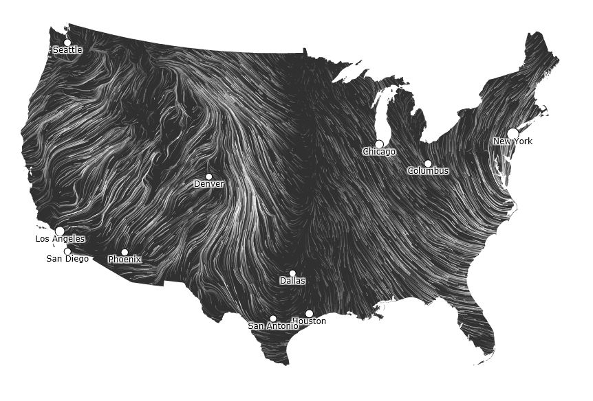
Just for fun, here is a picture of the current wind patterns in the US (11:59 CT 2/1). To find the live interactive wind map, navigate to the Favorite Links page on this blog.