Thursday, April 25, 2013

Thursday 4/25

Temperature: 39°F (High 48°F)
Humidity: 73%
Pressure: 1023.4 mb
Wind Speed: W 9 mph

When everyone has been waiting and expecting the warm weather to finally come and stay, the coldness just won't leave. Today is another chilly day, with a consistent west wind and altostratus clouds. The jet stream is in a meridianal flow pattern again, and Wisconsin is centrally located in the trough. This dip in the jet is allowing this cold weather to hang out a little bit. With less than a week left of April, I think there's a good chance we won't see 70°F before May.

Sunday, April 21, 2013

Sunday 4/21

Temperature: 44°F (Low 39°F)
Humidity: 71%
Pressure: 1019.9 mb
Wind Speed: E 6 mph

The never-ending winter continues. Today was a nother cold and dreary day. It was overcast all day, with low stratus clouds, sometimes producing some light precipitation. For everyone who is hoping that this weather will finally improve, don't hold your breath. There is another flurry of precipitation coming tonight, most likely only rain, it shouldn't get cold enough for snow. As you can see, directly to our west is a stationary front. Directly behind that is a large high pressure system that would clear some of this dreariness up, but that stationary front is keeping it in place.


If you hate this weather as much as I do, you can thank the jet stream. You can see that from the way it is positioned in, Eau Claire is sitting at the bottom of the trough. The divergence in the upper atmosphere is creating a void for the surface air to rush into. That air condenses into clouds and creates this consistent bad weather.

Tuesday, April 9, 2013

Tuesday 4/9

Temperature: 37°F (High 40°F)
Humidity: 96%
Pressure: 1017.4 mb
Wind Speed: NE 3 mph

Today is a very rainy day. Since about 9:00 this morning, there has been a consistent rain coming down. It's nothing torrential, but certainly not just a drizzle. Here in Eau Claire, everyone is preparing for a major flood to happen on the Chippewa River. Fortunately, it doesn't look like we'll see anything to extreme. I looked at the flood hydrograph for today (below) and even with the projected rainfall over the next 24 hours, we will barely come close to the "minor" flooding stage. In other words, the river is going to be high enough to be much more exciting than last spring, but we'll be safe from serious flooding. Below is the flood hydrograph from the Chipp. It can be found at the National Oceanic and Atmoshperic Administration website. The direct link is http://water.weather.gov/ahps2/hydrograph.php?wfo=mpx&gage=eclw3


Monday, April 8, 2013

Monday 4/8

Temperature: 37°F (High 46°F)
Humidity: 93%
Pressure: 1009.1 mb
Wind Speed: NE 3 mph

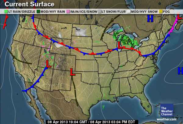
Today is a typical gloomy spring day. The sky has been covered with stratus clouds all day, and there has been quite a bit of humidity in the air, which was visible earlier in the fog. The temperatures have actually been pretty pleasant though, and there's hardly any wind. In Wisconsin, the temperatures are still fluctuating between warm and cold, and we're still waiting for the temperatures to heat up evenly all the up through the atmosphere. Right now, the upper atmosphere is still much colder than the surface temperatures, and we won't see constant warm temps until it warms. How does it warm, you ask? Well as the winds shift to the south, we will see more warm air come our way, but to really heat up the upper atmosphere, we need storms! The vertical growth of thunderclouds release immense amounts of energy high in the atmosphere, which helps to warm it up. There aren't any storms today, but hopefully we will be seeing some soon. There are some major low pressure systems that are constantly forming in Eastern Colorado (Colorado Lows) that could eventually bring some thunderstorms our direction. But today, there is a major stationary front serving as a wall that cuts off virtually the entire Midwest.


Also, if you don't know much about stationary fronts, you can imagine them as a very evenly matched game of backwards tug-o'-war against warm and cold air (in this case the cold air is trying push south and the warm is trying to push northward). If you look at the wind map, you can see that the winds are blocked by the stationary front and move parallel across it in the direction of the low.

Saturday, April 6, 2013

Saturday 4/6

Temperature: 45°F (High 49°F)
Humidity: 56%
Pressure: 1001.4 mb
Wind Speed: E 5 mph

Today is my favorite kind of day (cause I'm weird). It's warm outside, overcast, and looks like it will be raining (hopefully not snowing) by tonight. Yesterday started out sunny, but I noticed the classic warm-front related cloud progressions throughout the day. I noticed some high cirrus clouds in the morning, then early afternoon the cirrus clouds started to consolidate more into cirrostratus cloud which formed a large halo around the sun, then I knew the clouds were thickening and decreasing in altitude because the sun became a shapeless bright spot, and when I woke up today there was a thick layer of low stratus clouds which have been here all day. So at what time they will become nimbostratus is still up in the air, literally. Below is the projected forms of precipitation in the US. No more snow! No more snow!


Wednesday, April 3, 2013

Wednesday 4/3

Temperature: 35°F (Low 45°F)
Humidity: 37%
Pressure: 1029.8 mb
Wind Speed: S 8 mph

Today we have a moderate wind coming from the South, which is helping to warm up the temps after two cold days. The sky is mostly sunny with a few high cirrus clouds. The air being brought from the South is replacing the continental Polar air that has been around since Saturday. If you take a look at the location of the jet stream today, you can see that it dips down into New Mexico and Texas before bringing that warm air back our way. This warm air that comes from the South usually is pretty moist, so I wouldn't be surprised if we see some precipitation later tonight and/or into tomorrow.

Sunday, March 31, 2013

Sunday 3/31

Temperature: 31°F (Low 14°F)
Humidity: 45%
Pressure: 1014.2 mb
Wind Speed: NW 10 mph

Eau Claire experienced some fairly common March weather today on the last day of the month. It was rainy and even a little snowy in the morning, and it cleared up later in the afternoon when the winds shifted to the West and eventually Northwest. Around the nation today, it was pretty crazy. There was a major cold front that moved in from Canada, most likely associated with a Polar Continental air mass. There is also multiple low pressure systems, in the Northwest, around the Southwest and up the Rockies, Louisiana, and parts of the West Coast. Who says March goes out like a lamb?