Monday, February 11, 2013

Monday 2/11

Temperature: 27°F (High 30°F)
Humidity: 75%
Pressure: 1006.4 mb
Wind Speed: W 14 mph, Gusts up to 26 mph

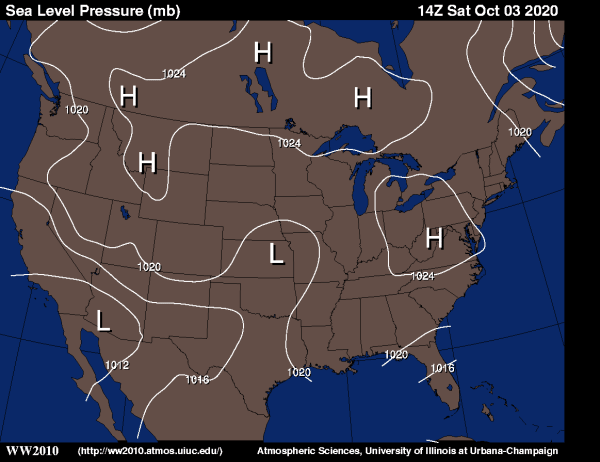
Well the pressure is lower than it has been the past week or so, which explains the cloudy conditions and the relatively high winds. If we take a look at the Sea Level Pressure map for today, we can see that Eau Claire and most of the Great Lakes area are in a large low pressure system. Also, we can see that the isobars are pretty close together over Eau Claire, which is why we are having fairly strong winds blowing towards the center of the low pressure system.


It seems as though that there is nothing but high pressure systems forming to the West of Eau Claire, so we can expect to see the sun a little bit more throughout the next couple of days. However, don't be surprised if we continue to get some dustings of snow, those Alberta Clipper systems are not finished quite yet.

Thursday, February 7, 2013

Thursday 2/7

Temperature: 25°F (Low 11°F)
Humidity: 81%
Pressure: 1022.5 mb
Wind Speed: N 8 mph

Today was a pretty crummy day. It was overcast all day, with fog in the morning and freezing mist at night. The Jet Stream was in a very geostrophic position, blowing straight West to East for the most part. This would explain the lack of strong winds and a relatively boring day of weather.

Thursday US Jet Stream

Wednesday, February 6, 2013

Wednesday 2/6

Temperature: 20°F (High 26°F)
Humidity: 85%
Pressure: 1019.2 mb
Wind Speed: SE 6 mph

As you can see, the winds changed directions today. Instead of blowing out of the Northwest like they have been recently, today they are coming from the Southeast. This change of wind direction seems to have brought some moisture along with it, because today Eau Claire is receiving a little bit of snow throughout the afternoons and into the night.


The Sea Level Pressure map doesn't show much activity in our neck of the woods. The isobars are relatively spread out, which explains the weak winds blowing from the SW towards the low pressure system in the Dakotas. I think we expect constant temperatures around 30°F for the next few days.

Tuesday, February 5, 2013

Tuesday 2/5

Temperature: 25°F (High 26°F)
Humidity: 78%
Pressure: 1009.9 mb
Wind Speed: NW 9 mph

Well my first forecast of the season was correct (albeit not a very risky one). I said the sun yesterday could create some evaporation, stratus clouds, and warmer temperatures, which is exactly what happened. Today has been overcast all day and temperature highs are 10° warmer than yesterday.

Over the past couple of nights we have been experiencing some light dustings of snow. These are called Alberta Clippers, which are moist air masses from the NW brought to the midwest by the jet stream. Given the location of the jet stream today (bottom right), it looks like it is in perfect position to bring some more of that precipitation from the Pacific (notice Washington, bottom left) our way once again.


US: Doppler RadarTuesday US Jet Stream

Monday, February 4, 2013

Monday 2/4

Temperature: 11°F (High 13°F)
Humidity: 56%
Pressure: 1018.5 mb
Wind Speed: Calm

Well today is a pretty calm, average day. Fairly chilly temperatures, but the bright sunshine and the lack of wind makes it a pretty enjoyable day.

As you can see from the Sea Level Pressure map from weather.unisys.com, Western Wisconsin is currently in a high pressure system. If I were to make any forecasts, I would say that the sunny skies will cause some evaporation of the snow, and we could see some cloudy, stratum type skies the next few days, along with warmer temperatures.

Sea Level Pressure Contour - Current

Friday, February 1, 2013

Friday 2/1

Welcome to the Becker Diurnal Weather Journal! Here on the Home Page I will be giving a daily (or near daily) rundown of recent and current weather conditions, as well as make short-term forecasts in the Eau Claire, WI area. I will provide current weather conditions based on information received by weather balloons sent up the National Weather Service station in Chanhassen, MN. For example, today's weather conditions are as follows:

Temperature: -6°F (High 0°F)
Humidity: 64%
Pressure: 1026.3 mb
Wind Speed: 7 mph

Also in my posts, I will talk briefly about the weather from the last few days or so, the current weather, and make a short term forecast. I will also include weather maps to illustrate my explanations.

It's been a wild week of weather here in EC. Sunday (1/27) saw fairly warm snow, and alot of it. Monday followed with unusually warm temperatures, and hard showers of rain in the evening and into the night. After a night of rain, Tuesday brought clear skies and very, very icy conditions. It was safer to travel with ice skates than by walking. Wednesday was similar to Tuesday, clear skies, light breeze, and more icy conditions. Thursday (yesterday) was blustery, with light snow in the morning, and decreasing temperatures throughout the afternoon and into to today, and let me tell you, it certainly is cold! Today we have a wind chill of -30°F! I can definitely say I'm happy to be inside reporting on the weather, not experiencing it.

Just for fun, here is a picture of the current wind patterns in the US (11:59 CT 2/1). To find the live interactive wind map, navigate to the Favorite Links page on this blog.