Wednesday, March 6, 2013

Wednesday 3/6

Temperature: 27°F (High 30°F)
Humidity: 58%
Pressure: 1027.7 mb
Wind Speed: NW 8 mph

It's the sixth day of March, and already I can't tell if spring is on the way or if winter is going to hold on for a little bit longer. Last week I thought temperatures were finally going to warm up for good, but this week we got another dumping of snow. Now is this going to be the last snowfall? Probably not. Now we've got so much snow on the ground, and as the weather starts to warm up, the snow is melting rapidly during the day and evaporating into clouds. My prediction, the huge ridge of high pressure will allow for clear skies the next couple of days, but when that moves, all the water vapor in the air is going to come right back down sometime this weekend. As for today, it's very sunny, with mostly clear skies except for a few cumulus humilis (fair weather) clouds.

US: Current Weather

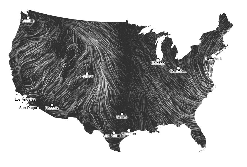
One more thing, I mentioned above that there is a huge ridge of high pressure headed our way. Well it's really cool to observe this ridge through the direction of winds. Winds always blow from high to low pressure, and on this wind map from today, you can see where the ridge is, from Northern Minnesota (probably even Canada) all the way down to Dallas, TX. Pretty cool, huh?

Monday, March 4, 2013

Monday 3/4

 
Temperature: 25°F (High 30°F)
Humidity: 63%
Pressure: 1017.3 mb
Wind Speed: E 13 mph

Storm's coming... The wind today shifted from the NW to an Easterly wind, and the clouds have dropped from high cirrus clouds to lower stratus clouds. These changes typically some severe weather is on the way. If you take a look at the wind map for today, you can see the wind is being drawn in from the East into the low pressure system that is currently in Western Minnesota. This same system is projected to hit Eau Claire some time tonight, and will likely dump around a foot of snow by tomorrow morning. Here's to hoping for a snow day!

Saturday, March 2, 2013

Saturday 3/2

Temperature: 26°F (High 29°F)
Humidity: 46%
Pressure: 1024.5 mb
Wind Speed: NW 3 mph
Today was not much different than yesterday was, just like I thought it would be. It was a fairly chilly day with some calm winds. If you notice the surface map of the United States, there doesn't appear to much activity going on anywhere. All of the isobars are spread out, especially out West. As a result, I think this weather will continue. I would expect highs in Eau Claire to be around 30°F again, and partly cloudy skies. I guess we'll find out.

US: Current Weather

Friday, March 1, 2013

Friday 3/1

Temperature: 24°F (Low 5°F)
Humidity: 57%
Pressure: 1027.3 mb
Wind Speed: N 6 mph

It's finally March! A high pressure system moved through Wisconsin today, and brought with cold winds from the North. The temperatures were cold throughout the day, and while the winds were not a that strong, it was certainly a cold wind. The morning and early afternoon had partly sunny skies with some cirrus clouds, but the evening brought some lower stratus clouds. There appears to be some more high pressure headed our way, so we will probably see some clear skies through the weekend.

US: Current Weather

Tuesday, February 26, 2013

Tuesday 2/26

Temperature: 35°F (Low 26°F)
Humidity: 67%
Pressure: 1011.6 mb
Wind Speed: NE 16 mph
Today is an overcast day with gusty conditions. The sky is blanketed with stratus clouds which are non-nimbus (no precipitation). The temperatures today were fairly warm, but the wind throughout the day made it feel quite a bit more chilly than the temps indicated. The Jet Stream dipped unusually far South today, which was an effect of the mid-latitude cyclone that went through the Great Plains yesterday and today. As for Wisconsin, everything is pretty uneventful. The Jet Stream is pretty much straigh West-East through the Midwest, and there doesn't appear to be any major precipitation headed our way.

US: Current WeatherTuesday US Jet Stream

Sunday, February 24, 2013

Sunday 2/24

Temperature: 34°F (High 34°F)
Humidity: 56%
Pressure: 1018.9 mb
Wind Speed: W 5 mph

Could it be!? Is there a chance we are finally going to be finished with the cold weather? I think it's true. It's a beautiful day today, with warm temperatures, clear skies, and hardly any wind. After Winter Storm Q came through on Thursday all we've seen is sunshine. Hopefully this nice temperature will continue into the Spring. As for this week, I think it's going to be fairly eventless weather-wise. The radar shows no precipitation headed our way, so expect more sunshine.

US: Doppler Radar

Friday, February 22, 2013

Friday 2/22

Temperature: 25°F (Low 17°F)
Humidity: 85%
Pressure: 1011.1 mb
Wind Speed: W 6 mph

Today Eau Claire got hit by the Northernmost extent of Winter Storm Q. We received between 5-6 inches of snow throughout the day, but for the most part, it was a pretty pleasant day (at least I thought so).  The effects of the storm have passed over the Midwest already, but from the water vapor map below you can see that the Tropical Jet Stream has been attracted upwards into Gulf of Mexico and the Southern states, which will be receive large amounts of precipitation.

US: Water Vapor Satellite